A recent paper documents the earliest known human use of freshwater and anadromous (migratory to spawn) fish in North America by 13,000 and 11,800 years ago, respectively, from primary anthropogenic contexts in central Alaska (eastern Beringia). Fish use appears conditioned by broad climatic factors, as all occurrences but one are within the Younger Dryas period. Earlier Bølling-Allerød and later early Holocene components, while exhibiting similar organic preservation, did not yield evidence of fishing, suggesting that this was a response to changing environmental factors…. Furthermoree, the paper claims that late Pleistocene and recent Indigenous peoples harvested similar fish (salmon, burbot, whitefish, and pike) in the region. The authors characterize late Pleistocene fishing in interior Beringia as an important element of broad-spectrum foraging rather than the intensive communal fishing.
I wrote to the paper’s primary authors to make them aware of the environmental changes at the Younger-Dryas boundary that account for their findings. They are found in my paper, “The Flooding of the Mediterranean Basin at the Younger-Dryas Boundary.” Its findings include: (1) identifying geology’s historic and far-reaching ‘no Flood’ error; (2) identifying and analyzing the Younger-Dryas impact that delivered the worldwide Flood waters (i.e., the Younger-Dryas event and the worldwide Flood are synonymous); (3) recognizing that humans are not out of Africa – we are from landscapes now submerged under more than two miles of water; (4) recognizing that humans are ill-adapted to the post-Flood ecosystem and that our continued survival necessitates environmental abuses.
A model of land and sea distributions in pre-flood Earth (Fig. 8 of my paper) is shown, below, along with a red oval that identifies Beringia. Map colors and their indications are: tan (previously exposed but now-submerged landscapes), beige (presently exposed landscapes), and blue (former oceans and seas).

The map shows that, prior to 12,800 years before present, those humans occupying the Tanana and Beringia had no anadromous fish to exploit – the pre-Flood Pacific Ocean was blocked by what is now the Aleutian atoll (a pre-Flood mountain range), and its waters were too far from the region. After the Flood (12,800 ybp), the region had proximate access to anadromous fish, once their populations adjusted to their vastly expanded habitats. This accounts for the paper’s findings.
We should also note that pre-Flood human endeavors into the region were likely brief, not only because of its northern latitude, but also because the region would have been on the order of 50oF cooler since it was more than two miles above the pre-Flood abyssal landscapes. (Related discussions found here and here.)
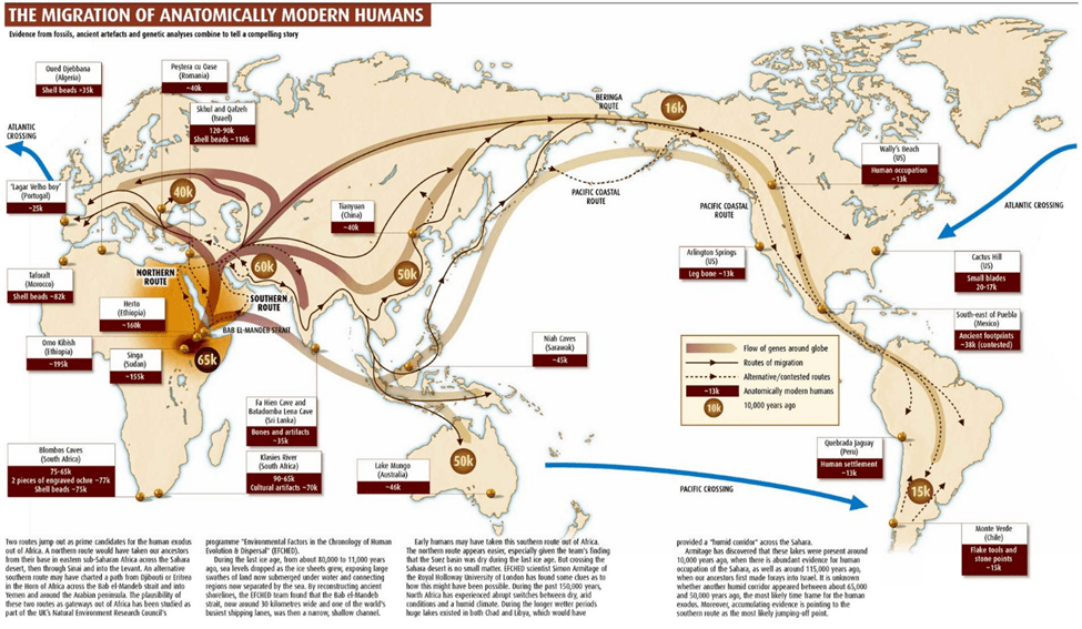
I am quite aware of the extent to which “no Flood” permeates academia. For instance, Maps depicting human migrations, like the one from TransPacificproject.com, below, are based on the prevailing “no flood, ever” paradigm. Note that the map shows migrations into North America through Beringia, taken as “known” by the authors of Freshwater and anadromous fishing in Ice Age Beringia.
Data for such maps come from research like “A DNA Search for the First Americans Links Amazon Groups to Indigenous Australians,” reported in a 2015 Smithsonian article. There we find the next map displaying, by color, DNA similarities among indigenous humans (dark = closely linked, clear = not closely linked). Note that native Australians are closely linked to native South Americans.

In the Smithsonian article, we read:
“More than 15,000 years ago, humans began crossing a land bridge called Beringia that connected their native home in Eurasia to modern-day Alaska. Who knows what the journey entailed or what motivated them to leave, but once they arrived, they spread southward across the Americas.
The prevailing theory is that the first Americans arrived in a single wave, and all Native American populations today descend from this one group of adventurous founders. But now there’s a kink in that theory. The latest genetic analyses back up skeletal studies suggesting that some groups in the Amazon share a common ancestor with indigenous Australians and New Guineans. The find hints at the possibility that not one but two groups migrated across these continents to give rise to the first Americans.”
Thus, according to the article, and as depicted in the migration map, we are supposed to believe that, during the last ice age, native Australians made their way northward! more than 10,000 km through Asia, crossed an hypothesized land bridge through either the Bering Strait or the Aleutian Atoll, then made their way more than another 10,000 km to South America – all the while doing this without leaving their DNA signature? Impossible.
A correct explanation for the native Australians-South American DNA similarities has nothing to do with migrations; instead it has to do with surviving the worldwide flood, described in my paper. That is, pre-flood humans from the same “clan” spanned the tropical to near-tropical expanse from Australia to SA, and flood survivors from the eastern and western extents of the region bear the family’s DNA signature. Related materials regarding Lemuria (and COL James Churchward’s work) can be found here.
The primary findings in “Freshwater and anadromous fishing in Ice Age Beringia” support my claim: there was a worldwide flood. Yet the authors try to fit them into the “Beringia” land bridge hypothesis, an unfortunate consequence of “no Flood.”
We completely misunderstand where we are from, what we are, and what has happened to our planet because of Geology’s historic and far-reach “no Flood” error. Anthropology, Archaeology, and Geology, are in need of fundamental reform.
