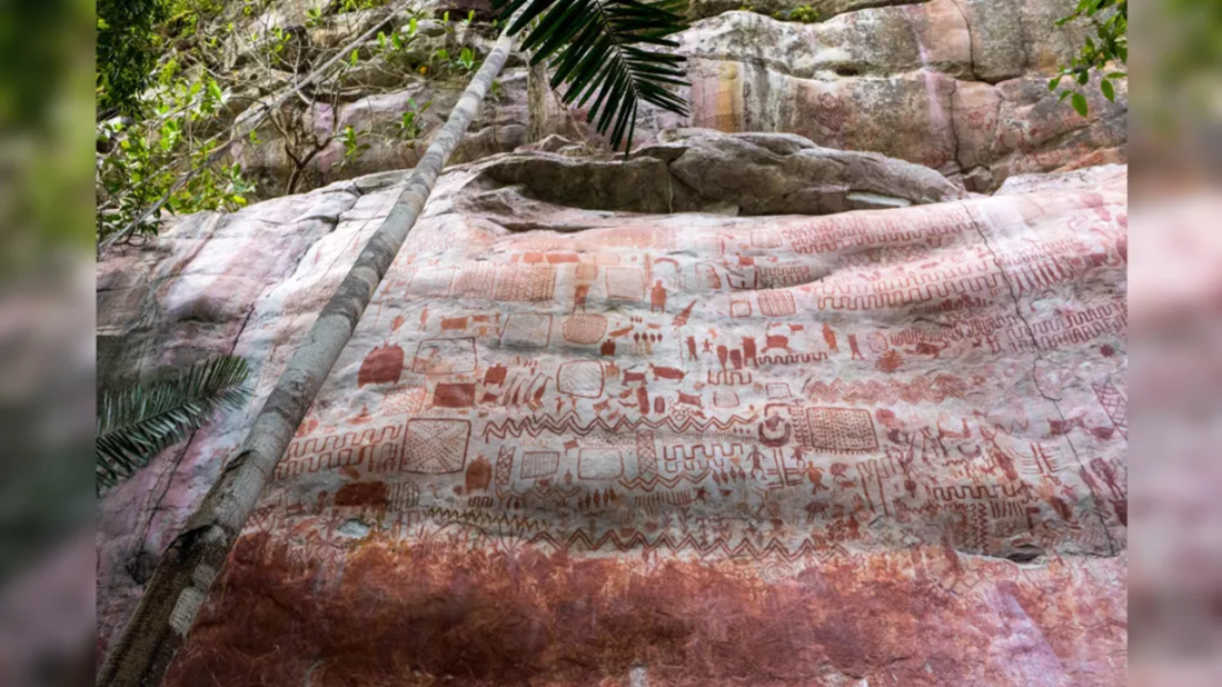
In a previous post, I discussed the immense mural found in the Colombian Amazon, as well as an interaction that I had with the researchers who discovered it. In this post, I will interpret some of the mural contents from the perspective that there was a worldwide flood and that ensuing ecosystem changes made survival difficult for most animals, especially so for those that inhabited the former abyss.
I will concentrate on a portion of one of the images found in many articles reporting the discovery of the mural. A few comments before doing so: (1) Some of the articles mention that the Amazon was transforming from savannah to rain forest at the time the mural was created. This is correct; the introduction of the worldwide flood waters 12,800+/- years before present – essentially the same time as the mural’s creation – induced planet-wide climate changes and, therefore, local environmental changes. (2) Some articles claim that humans hunted some species to extinction. This is incorrect: all known extinctions at this time (e.g., the Younger-Dryas extinctions) were caused by changed environments.
In this analysis, I assume that time moves upward, that triangular waves represent water, and that rectangles represent landforms. Here is a portion of the mural found in many of the articles reporting the mural’s discovery.

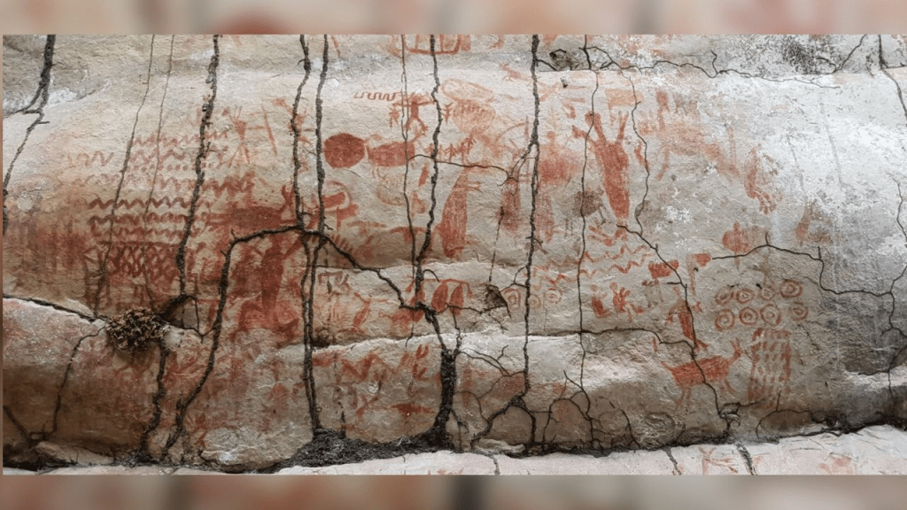
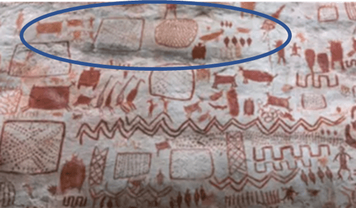
In the blue oval, below, is a region of pre-Flood Earth with which the mural’s author(s) was(were) familiar. To the left is a large land mass (square with dots aligned in an X pattern). Perhaps the dots inside the square represent trees, or maybe the interior pattern is meant to convey the shape of mountains. This region was separated from other landforms by a ridge (vertical lines enclosing cross hatches). In the center of the oval were two major inhabited areas that included water, animals such as deer, and humans. I am not sure what the square waves (on the right) represent, though I suspect it could be an uninhabitable region because humans lived outside it (below and to its right).

The next oval captures the Flood’s effects. Note that the introduction of the water has covered the ridges, one of the square landforms that was between them, and most of the uninhabitable regions (square waves). Note that the animals are headed toward the central square! They were flushed out of their natural domains by the water, and they headed toward survival on dry land.

By the way, this explanation accounts for the diversity of creatures found in the Galapagos Islands – non-indigenous species survived upward and those that could adapt are now found mixed in with indigenous species.
In the next image, the arrows capture the time evolution of the two land masses that remain exposed after the Flood. If the dots inside the square represent trees, then it demonstrates the transformation of the region associated with the yellow arrows from steppe to rainforest.

In the uppermost oval we observe that a subset of the animals from the central oval is leaving the region. This might represent the extinction of some species. In addition, the outward migration reflects that some surviving species could not adapt to the region’s Flood-induced ecosystem changes. (Note that the four-legged creature with large ears found in all three ovals survives the ordeal. Could it be a flying squirrel or a bat?)
Hand prints in another image are found above the triangular wave. The meaning: I am human, I survived the Flood, and I wanted you to know.
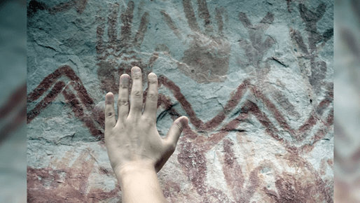
Also, it appears that pre-Flood vegetation (plant leaves below the triangular wave and to the right of the hand) differs from the vegetation that survivors encountered afterward, depicted to the right of the hand prints. It would be fascinating to understand the human pre-Flood diet and how it differs from what we now consume….
Does the mural depict the IO’s appearance and debris trail on Earth approach?
In my paper (and book), I refer to the celestial object that delivered the Flood as the IO (impacting object). It was very large, about 1500 miles in diameter, and it was made up primarily of loosely compacted ice chunks. It was loosely packed due to very small gravitational accelerations (relative to Earth) induced by its solid core that attracted ice and other debris in the Oort Cloud where it formed. The IO would have been visible for many years prior to its impact, and, along its way, the Sun’s gravitational acceleration and other forces would cause the IO to shed some chunks that we now call comets. Its sun-illuminated approach would have made a lasting impression….

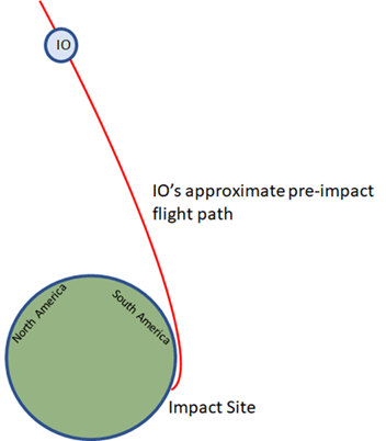
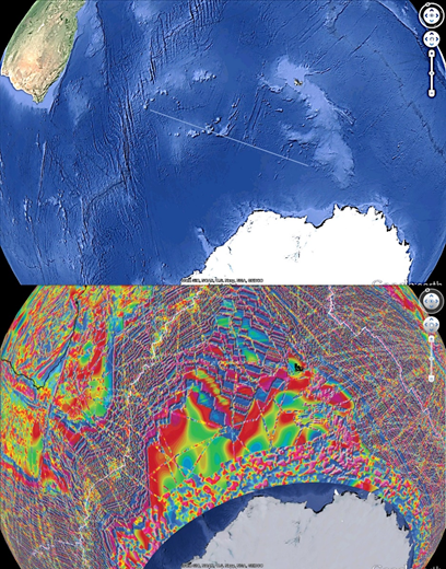
The IO’s path led to its capture by Earth’s gravity, as well as its ensuing impact in what is now the Southern Ocean. Back-propagating the IO’s core impact trough reveals that its pre-impact approach path overflew North America, Central America, and South America. Schematics of the approach path are shown, below. The first is a side view showing that the IO was highest over North America during approach, which would account for the continent-wide spread in its debris field (from off the Monterey, CA, coast to the Carolina Bays).
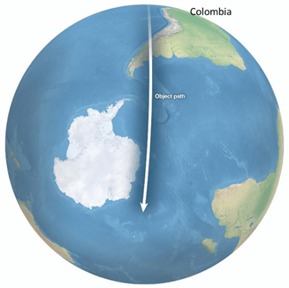
The second depicts the IO’s core overflight “shadow” just prior to impact.
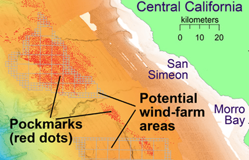
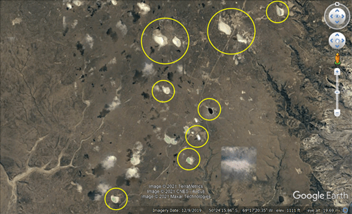
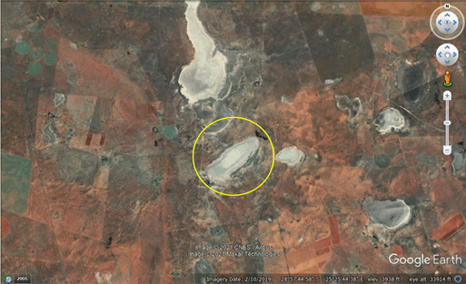
On its approach, the IO would shed a long tail of debris that created impact craters in North America, South America, and South Africa. Examples of impact craters are shown below:
Carolina Bays (North America):

California coast (North America):
Colombia (South America):

Argentina (South America):
South Africa:
The fragile IO split in two just before impact, and this accounts for the gap in the impact crescent.
The IO split was also recorded in a South African cave painting, shown below and described here.

Why all this? Because the mural tells the story of what survivors encountered, and it is nearly certain that they witnessed the debris that rained down as the IO flew overhead. As such, I strongly suspect that somewhere in the mural is a depiction of the debris storm.
Two final comments:
- It would be interesting to know if anyone was “in charge” of the mural, as well as how many years it captures.
- The Flood completely changed the Earth, it created a horrific scenario for inhabitants, and survivors wanted to tell their story. The Amazon mural is another commemoration of the event.