Background: the Ganges river system
A recent paper reports the discovery of ancient wood chips in a sediment sample obtained from the Bay of Bengal. The authors conclude that “woody debris can survive thousands of kilometers of transport in rivers and in turbidites, to be deposited in the fan.” (Lee et al, 2019)
The notion that millions-year old wood could be found at various depths in the sediment column (meaning that the deposits occurred many years apart) – at the exact same location, more than a thousand miles from shore and more than two miles below present sea level – should cause the authors, reviewers, and any scientist to question the matter. For, what is the probability that trees would float to the exact same spot, thousands of miles from the present coastline, sink more than two miles, and then become quickly covered in sediment so as to survive for millions of years? How did the sediments get there? Where did the sediments originate? What mechanism transported the tree-preserving sediments through the Bay’s essentially stagnant water?
All rhetorical questions because the idea that the trees became submerged thousands of miles from shore is as absurd as thinking that Monterey Canyon was created by subsurface flows. The paper’s claim is yet another example of geologists fitting observations to their erroneous “no Flood, ever” paradigm. It is fantasy masquerading as science. The ridiculous findings prompted me to investigate the matter.
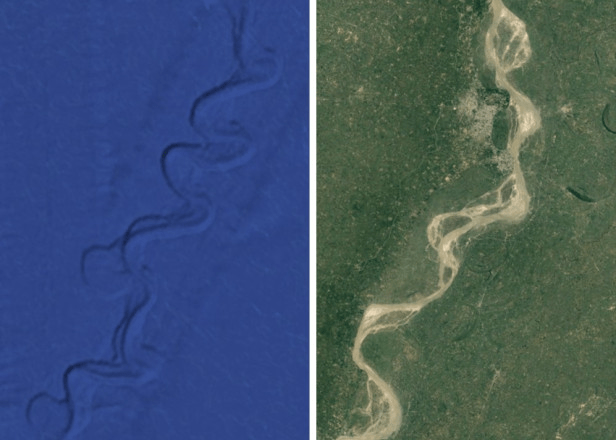
The drill region from which the paper’s cores were obtained is shown on the Google Earth image, below (left, centered vic 7.91°N, 85.854°E). There we observe a former river bed with its oxbows, found nearly 4000 m below sea level and 1600 km south of where the Ganges River presently drains into the Bay of Bengal. The map to its right is a portion of the post-Flood Ganges drainage (centered vic 26.732°N, 82.252°E and rotated 90o clockwise from north for comparison). Each displayed region measures roughly 30 km by 50 km and is viewed from a height of approximately 90 km. (Google Earth, 2020)
The ship that obtained the cores also mapped about 1500 km of the bay’s floor over an extensive track oriented mainly north-to-south. Its path can be observed on Google Earth; segments are identified by orange parallel lines in upcoming maps. Several portions of the ship track reveal oxbows of the pre-Flood Ganges.
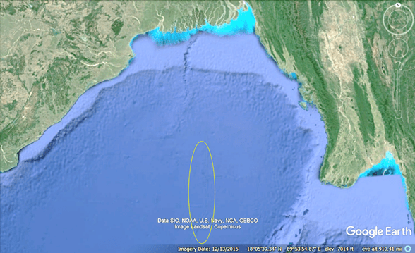
The next map is a screenshot of the Ganges system draining into the Bay, as well as where it once flowed down the continental shelf (top center). The light blue/aqua coloring denotes the extent of the post-Flood sediment deposit in the bay (sediments do not transport through essentially stagnant water!). Gravity brought the pre-Flood Ganges waters from the higher plain, down the continental shelf, and then into the formerly subaerial abyss. We can identify its oxbows in parts of the yellow oval.
The region in the yellow oval is shown in following two maps, one with superimposed icons depicting the ship track sounding region with orange lines and yellow arrows that identify pre-Flood Ganges meanders. [Note: depth, and lat, lon locations for map centers are shown in the lower right of the Google Earth screen captures in each of the following maps.]

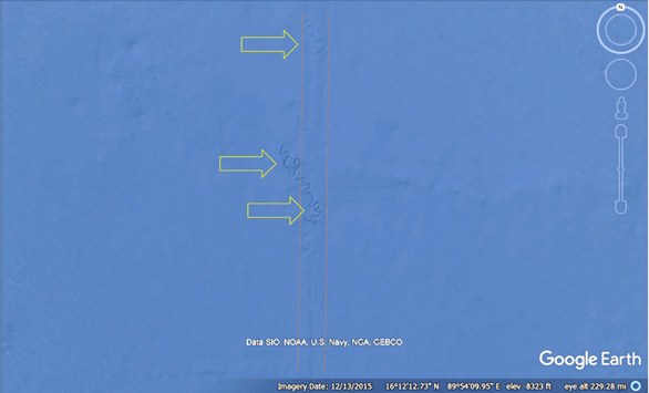
We follow the ship track southward in the next several images, and we discover more meanders and oxbows.
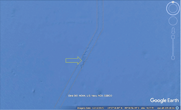
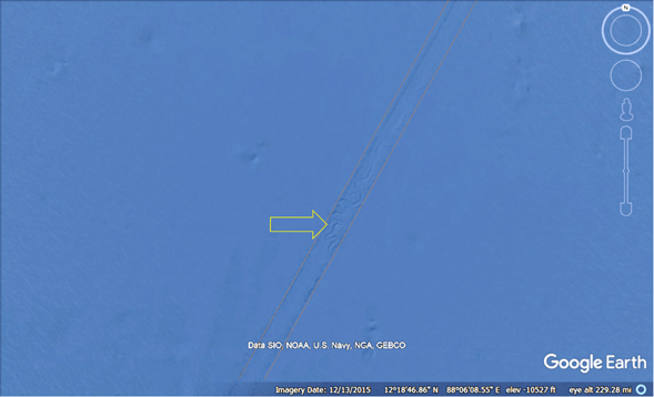
The ship track ends near the following map center where we observe the oxbows from which the paper’s cores were obtained (left side of first image, above).
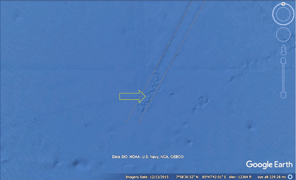
Note that the depth of the oxbows decreases as we moved from north to south (-8323 ft, -9177 ft, -10527 ft, and -12364 ft). This should not surprise us – the pre-Flood Ganges waters followed the path of least resistance while accelerating due to gravity.
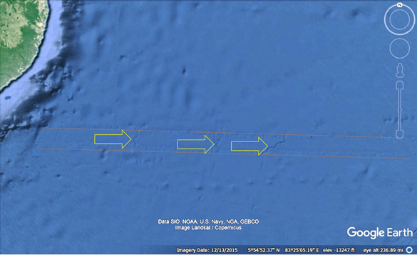
A bit further south, another ship track sounding with an east-west orientation reveals other river systems, identified again by the yellow arrows. Note that the riverbeds have essentially north-south orientations. (I believe that the Ganges is the system furthest east.)
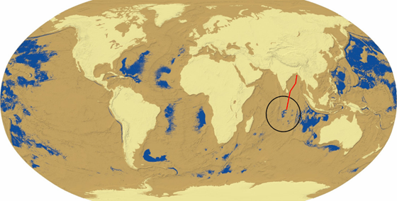
Based on the riverbeds found in the ship track soundings in the above maps, we can piece together that the Ganges flowed from its mountain source region, through presently subaerial landscapes, down the shelf, and then through thousands of abyssal kilometers. The estimated pre-Flood Ganges River path is depicted by the red line on the next map.
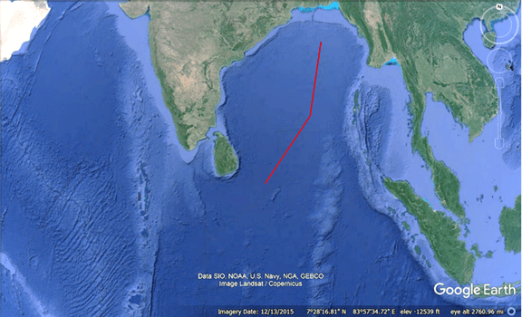
The Ganges water would eventually drain into a pre-Flood sea. It is circled in black on the map, below, and the approximate path it followed is depicted in red. (The pre-flood Earth map comes from my paper, “The Flooding of the Mediterranean Basin at the Younger-Dryas Boundary,” that addresses the worldwide flood and geology’s historic “no flood, ever” error.)
We should note that this formerly subaerial river system explains why we find millions-year old tree remnants submerged in various sediment layers thousands of miles off the present shoreline: the trees were carried by the Ganges, then buried and preserved by the river’s sediments over the millions of years prior to the region becoming submerged by the worldwide flood.
Sacred Ganges
For tens of thousands of years, perhaps hundreds of thousands of years, the Ganges provided life-supporting water to humans occupying pre-Flood abyssal regions beneath what is now the Bay of Bengal. It is very likely that humans from the region shared a common culture. No doubt, some ventured to upland Ganges plains that would have necessitated some sort of clothing for warmth, perhaps the origin of khadi clothing. (Note: the adiabatic lapse rate would have the pre-Flood upland region about 35oC cooler than abyssal landscapes.)
The Flood’s survivors either made their way up the continental shelf, or they occupied the upland plains (that remain subaerial) when the Flood-delivering impact occurred. There, the Ganges would continue to provide requisite water. Portions of pre-Flood culture would have survived as well, which would account for the river’s reputation.
I suspect that Flood legends exist in Indian historical traditions. As such, this essay should be of interest to those responsible for maintaining them.
Bibliography
Google Earth: left, centered vicinity 7.91°N, 85.854°E; right, vicinity 26.732°N, 82.252°E. Google Earth, earth.google.com/web/.
M. Jaye, The Flooding of the Mediterranean basin at the Younger-Dryas boundary. Mediterranean Archaeology and Archaeometry, 19(1), 71-83 (2019).
H. Lee, V. Galy, X. Feng, C. Ponton, A. Galy, C. France-Lanord, S.J. Feakins, Sustained wood burial in the Bengal Fan over the last 19My. Proceedings of the National Academy of Sciences 116, 22518-22525 (2019).
